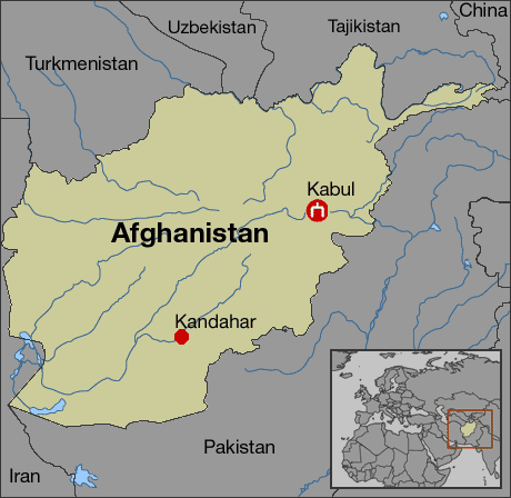
Kabul is over 3,500 years old and many empires have controlled the city which is at a strategic location along the trade routes of South and Central Asia.
The area in which the Kabul valley sits was ruled by the Medes before falling to the Achaemenids. There is a reference to a settlement called Kabura by the rulers of the Achaemenid Empire, which may be the basis for the future use of the name Kabura by Ptolemy.
It became a center of Zoroastrianism followed by Buddhism and Hinduism. Alexander the Great explored the Kabul valley after hisconquest of the Achaemenid Empire in 330 BC.
It has been ruled by the Achaemenids, Seleucids, Mauryans, Kushans, Kabul Shahis,Saffarids, Ghaznavids, and Ghurids. Later it was controlled by the Mughal Empire until finally becoming part of the Durrani Empire with help from the Afsharid dynasty.
(2) Kabrahata
Iron bearing megalithic site in MP.
Similar other sites are Dhanora, Chirachori, Sonabhir, Handaguda, Nelakanker, Timmerwada, Sorara, Majagahan .
(3) Kaimu
It was under Magadha Empire, Guta rulers, Harshawardhana and later under Pal dynasty.
Huen Tsang had passed through Arrah.
In 2012, erotic scultures were excavated in Baidyanath village.
(4) Kakoria
A megalithic chalcolithic site in eastern UP.
(5) Kaladi / kalady
Near Cochin city.
Birthplace of Adi Sankaracharya, Hindu theologian and exponent of the Advaita Vedanta philosophy who established first Matha in Sringeri, Karnataka.
(6) Kalako deray
In Swat Valley.
Grave sites and associated settlements of mid 2nd millennium BCE have been recovered.
(7) Kalanaur
In Gurdaspur district in Punjab
During the 14th-16th centuries, Kalanaur was a major urban centre and several historical events are associated with the town.
Firuz Shah Tughluq (1352–88) built a beautiful palace on the banks of the Kiran rivulet.
During the reign of Sayyad Mubarak Shah (1421–35), Kalanaur was ruled by the Khokhar tribe.
In February 1556, Mughal Emperor Akbar, was enthroned in a garden near the Kalanaur by Bairam Khan. The masonry platform, where he was crowned can be visited even today, as can a mosque that was built during the his reign. This is the crowing platform of the Mughal emperor "Akbar the Great" at Kalanaur, distt Gurdaspur in Punjab
Later, when the area was annexed by Ranjit Singh.
(8) Kalibangan
Kalibangan is a town located on the left or southern banks of the Ghaggar (Ghaggar-Hakra River), identified by some scholars with Sarasvati River Hanumangarh district, Rajasthan.
Kalibangan was a major provincial capital of the Indus Valley Civilization. Kalibangan is distinguished by its unique fire altars and world's earliest attested ploughed field.
Other nearby sites belonging to IVC include Balu, Kunal, Banawali etc.
Proto-Harappan Phase
Indus Valley culture existed at the site from the proto-Harappan age (3500 BC - 2500 BC) to the Harappan age (2500 BC - 1750 BC). This earlier phase is labelled Kalibangan-I or Period-I.
Similarity of pottery relates Kalibangan-I with the Sothi culture because this type of pottery was first discovered at Sothi village in North Western India.
Fort and houses:
In this phase, the settlement was fortified, using dried mud bricks, from the beginning of occupation. Brick size was 20 × 20 × 10 cm. The citadel mound (smaller mound) is a parallelogram about 130 meters on the east-west axis and 260 meters on the north-south. Town planning was like that of Mohenjodaro or Harappa. The direction of houses and brick sizes was markedly different from that used in the Harappan phase (KLB-II).
Within the walled area, the houses were also built of mud bricks of the same size as used in the fort wall; the use of burnt bricks is attested by a drain within the houses, remains of ovens and cylindrical pits, lined with lime plaster. Some burnt wedge shaped bricks also have been found.
Earliest ploughed field:
It has been found outside the fort. It shows a grid pattern of furrows, placed about 30 cm apart running east-west and other spaced about 190 cm apart running north-south. Even today, similar ploughing is used for two simultaneous crops in this region, esp. of mustard and gram.
Evidence of wooden furrow
Pottery:
Pottery, characterized by six fabrics labelled A, B, C, D, E and F, which were first identified at Sothi in North Western India.
Fabrics A, B, and D can be clubbed together. They are red painted. Fabric-A is carelessly potted in spite of use of potter's wheel. It contains designs in light-black, often decorated with white lines. Lines, semicircles, grids, insects, flowers, leaves, trees and squares were favourite motifs. Fabric-B shows marked improvement in finishing, but the lower half was deliberately roughened. Flowers, animals were painted in black on red background. Fabric-D contained designs of slanted lines or semicircles in some, while most pots were plain.
But Fabric-C pottery was thicker and stronger, fine polish, with designs in black; it is the best proto-Harappan pottery in finishing. Fabric-E was light colored and Fabric-F was grey.
Other finds:
Small blades of chalcedony and agate; beads of steatite, shell, carnelian, terracotta and copper; bangles of copper, shell and terracotta; terracotta objects like a toy-cart, wheel and a broken bull; quem with mullers, a bone point, and copper celts, including an unusual axe, etc.
Toy carts suggest carts were used for transportation in early phase of Kalibangan.
Earliest earthquakes & end of Phase-I:
There occurred an earthquake around 2600 BC, which brought to an end the Early Indus settlement at the site. At least three pre-historic earthquakes affecting the Indus Valley Civilization at Dholavira in Khadir have been identified during 2900–1800 BC.
Harappan Phase(Kalibangan II)
Fire altars:
At Kalibangan, fire altars have been discovered, similar to those found at Lothal. These altars suggest fire worship or worship of Agni, the Hindu god of fire. It is rare Indus Valley Civilization site where there is no evidence to suggest the worship of the mother goddess.
Within the fortified citadel complex, the southern half contained many (five or six) raised platforms of mud bricks, mutually separated by corridors. Stairs were attached to these platforms. Rectangular or oval kundas or fire-pits of burnt bricks for sacrificial altar have been found, with a sacrificial post (cylindrical or with rectangular cross-section, sometimes bricks were laid upon each other to construct such a post) in the middle of each kunda and sacrificial terracotta cakes (pinda) in all these fire-pits.
Houses in the lower town also contain similar altars. Burnt charcoals have been found in these fire-pits.These altars are perhaps intended for some specific (perhaps religious) purpose by the community as a whole. In some fire-altars remnants of animals have been found, which suggest a possibility of animal-sacrifice.
Thus, fire-altars have been found in three groups : public altars in the citadel, household altars in lower town, and public altars in a third separate group.
A short distance from fire altars, a well and a bathing place were found, suggesting ceremonial bath was a part of rituals.
Lower town:
The lower town was also a fortified parallelogram. The fort was made of mud bricks (40 × 20 × 10 cm) and three or four structural phases have been recognized. It had gates in north and west.
Well-regulated streets were oriented almost invariably along with the cardinal directions, thus forming a grid-iron pattern. Even the widths of these streets were in a set ratio, i.e. if the narrowest lane was one unit in width, the other streets were twice, thrice and so on. Such a town-planning was unknown in contemporary West Asia.
An east-west road ran in a curved outline to meet the first at the north-eastern end (towards the river), where a gateway was provided. This road was an anomaly in the grid-pattern of straight roads.
Fender posts were installed at street corners to prevent accidents.
In second structural level, roads were laid with mud tiles. Drains from houses emptied into pits (soakage jars) beneath the roads. Some central authority must be there to plan and regulate all this.
Housing:
Like town planning, housing also followed the common pattern of other Harappan cities. Due to grid-pattern of town planning like a chess board, all houses opened out to at least two or three roads or lanes.
Each house had a courtyard and 6-7 rooms on three sides, with a well in some houses. One house had stairs for going to the roof. Many houses had their own well
Houses were built of 30 × 15 × 7.5 cm mud bricks (same as those used in second structural phase of fort wall).
Burnt bricks were used in drains, wells, bathing platforms and door-sills, besides fire-altar.
Floors of rooms were built of thrashed fine mud, sometimes laid with mud bricks. One house had floors built of burnt tiles decorated with geometrical designs.
Evidence of camel bones.
Terracota:
Some early Kalibangan pottery has close resemblance to the pottery of the Hakra ware in Cholistan, to other Early Harappan pottery from the Indus Valley Civilization.
Functionally, pottery can be classified into household pots, religious and burial purposes.
Structurally, plain and decorated wares. Some pots had Harappan inscriptions on them.
Terracota figure is that a charging bull which is considered to signify the realistic and powerful folk art of Harappan Age.
The numerous terracota bangles found here.
Seals:
Most noteworthy is a cylindrical seal, depicting a female figure between two male figures, fighting or threatening with spears.
There is also a mixed person bull observing. They are of rectangular shape.
Other finds:
A cylindrical graduated measuring rod and a clay ball with human figures, Peas and chikpeas.
Burial systems:
Three systems of burial have been attested in the burial ground south-west of the citadel, where 34 graves have been found :
Burial in rectangular or oval pit, with corpse laid down straight, head northwards amidst pottery. In one pit a copper mirror was found among these objects. Pits were mud filled after burying. One grave was enclosed with a mud brick wall plastered from inside. One child had six holes in the skull.
Burial in pot (urn) in a circular pit, with no corpse. Pots and utensils were placed around the main pot (urn). In some graves beads, shell, etc have been found.
Rectangular or oval grave-pit, containing only pottery and other funerary objects. Like the first type, the length of this type of graves was also along north-south. The latter two methods were not associated with any skeletal remains and may be related to symbolic burial, not found at other Harappan towns. The third type of graves contained objects as in the second type but no corpse.
End of civilization :
Radiocarbon dates indicate that the Mature Harappan settlement at Kalibangan had to be abandoned around 2000–1900 BCE. And, as the hydrological evidence indicates, this abandonment took place on account of the drying up of the Sarasvati (Ghaggar).
(9) Kalinganagar
(10) Kalinjar
(11) Kalpi
It is in Jalaun district, UP on the bank of Yamuna. Kalpi is said to have been founded by King Vasudeva at the end of the 4th century. In 1196 it fell to Qutb-ud-din Aybak. During Akbar's reign, Kalpi was a governor's seat and had a mint for copper coinage.
About the middle of the 18th century it passed into the hands of the Marathas. It was captured by the British in 1803.
Recently a prehistoric site has been found dated back to 45000 years.
The name Assam comes from “Ahom” the dynasty ruled here from 13th century up to 19th century. Before that it was known as Pragyotishpur / Pragjyotisha and during the period of Ahoms conquest it was known as Kamrup.
Pragjyotispur was the capital of Kamrupa(900 B.C TO 1699A.D)
The earliest mention of the city of Pragjyotishpur may be traced to the Mahabharata and Ramayana.
‘Prag' means ‘Eastern' and ‘Jyotisa' means ‘light'. ‘Pragjyotispur' means "the city of eastern light or astrology". The 'Nabagraha' temple at Guwahati, which is dedicated to the nine planets or grahas speaks volumes for the development of the science in early Assam.
For nearly 2,500 years between 900 BC to 1699 AD Assam was in the midst of world commerce. Centrally situated on the land routes from eastern Kamboj to western Kashgar and from northern China to southern Ceylon. Chang Kien, a Chinese explorer traces his country's trade links with Assam as far back as 100 BC. According to the Periplus of the Eastern Sea, Assam silk like Muga and 'Pat' reached the kingdoms of Egypt and Rome and was as famous as Chinese silk and Tibetian pasmina. The weavers of Pragjyotisha thus made their country wealthy.Assam has been often referred to as the land of the Golden Sands.
The Kamakhya Temple is a Hindu temple dedicated to the goddess Kamakhya, The first epigraphic notice of Kamakhya is found in the 9th-century Tezpur plates of Vanamalavarmadeva of the Mlechchha dynasty.The Kamarupa kings from Indra Pala to Dharma Pala were followers of the Tantrik tenet and about that period Kamakhya had become an important seat of Tantrikism.As a result of this royal patronage, Kamakhya soon became a renowned centre of Tantrik sacrifices, mysticism and sorcery. That system of mystic Buddhism, known as Vajrayana and called "Sahajia cult", found its way into Kamarupa in tenth century.It is found from Tibetan records that some of the eminent Buddhist professors in Tibet, of the tenth and the eleventh centuries, hailed from Kamarupa.
(17) Kampil
(18) Kampili
(19) Kamatapura
(20) Kanauj (Kanyakubja)
Kanchipuram
Kanchivaram
Kandhar
Kangra/Nagarkot/Trigarta/Bhimnagar
Historically known as Nagarkot and Trigarta, Kangra was founded by Katoch Kshatriya Rajputs of Chandervanshi Lineage . The Katoch Rajas had a stronghold here, with a fort and rich temples.
The temple of Devi Vajreshwari was one of the oldest and wealthiest in northern India.
Mahmud of Ghazni took the fort in 1009 and from one of the temples carried off a vast treasure. In 1360 Kangra was again plundered, by Feroz Shah Tughluq.
After invading and occupying Kumaon and Garhwal in 1790, the Gurkhas invaded Kangra in 1806 and occupied it until the British took it back in 1815.
Kanheri -(Location near Mumbai)
Kanhwa/Khanwa
Kanyakumari
Kapilvastu
Kara
Kargil
Karle
Karnal
Karnasuvarna
Kashi- (Same as Banaras)
Kashipur
Katehar
Kathotia
Near Mandla, District: Narsinghpur, MP
Mesolithic rock painting depictin hunting and animal scenes.
Katpalon
Katni / Mudwara / Murwara
A town on the banks of the Katni River in Madhya Pradesh.Katni is a conglomeration of culture from three different cultural states viz. Mahakausal, Bundelkhand, and Baghelkhand.
Various Historical places of Katni
Bahoriband:
A statue of Jain Teerthankar Shantinath. There is some scripture of 12th century.
A stone has been found in which 10 incarnation of Lord Vishnu has been painted. There are so many statues of Narayan Shaishayani (bed) and sun (Lord Surya).
Tigavan:
Aalha and Udal has fought with king of Madhogarh in Tigavan. A Temple of 1500 year old can be seen, which is a flat ceiling temple. There is a statue of lord Narsing and on other side of wall there is Jain Treethankars Parshvanath statue.
Vijaraghavgarh:
33 km from Katni, Vijaraghavgarh is a historical place. A temple of lord Vijayaraghavgarh and the Vijayaraghavgarh fort
Roopnath:
Roopnath is a pilgrimage place 3 km from Bahoriband there is Panchlingam statue of lord Shiva and called as Roopnath. Sita Kund, Ram Kund, Lakhman Kund
There is verse painted on big stone that may be of 232B.C. some order like is written in Pali language for following Buddhism. It describes that 2½ years of Ashoka following Buddhism but nothing has been achieved so far.
Bilhary:
Many scriptures are found in this area there were so many temples the only remain is Varah temple of lord Vishnu. There is one more temple around one km from Bilhari of lord Shiva
Jhinjhari:
3 km from katni around 14 big colored painted rock are scattered they are all of prehistoric time. Ancient human painted all the animals found around here viz. Cow, Bull, Deer, Dog, Goat, Pork Hippopotamus etc. Hippopotamus is believed to be here in the ancient time. There are paintings available about fighting tools and man and woman, tree, flower. These painting are believed of 10000 BC to 4000BC some of the picture are of middle age 700 BC to 200 BC
Kaushambi
Kaveripattinam (Same as Puhar in Part P)
Kayal
Kayatha
Khairadih
It is in Balia district on Saryu river
It yielding remains of early CE such as street, lanes, a two room house and a underground structure
BRW, BSW, NBPW, GW, RW, & Kushana Periods
Khajuha
Khajuha is a historical town in Fatehpur District, UP.It is a very old town. Its description has been found in the old Hindu scripture "Brahm Puran", which is 5000 years old.
Khajuha witnessed one of the fiercest battles ever fought in India. At the battle, which took place on 5th January 1658, Aurangzeb decisively won over his brother, Shah Shuja
Aurangzeb's Pavilion,compound known as Bagh Badshahi
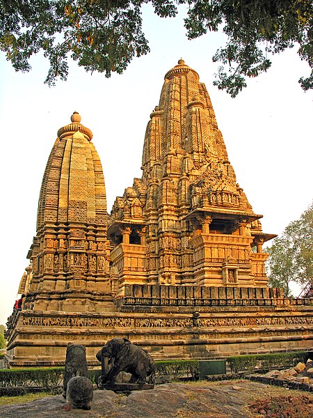
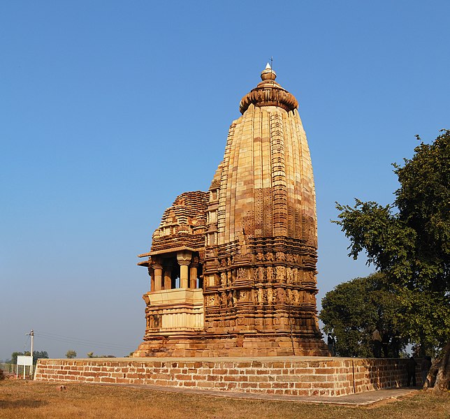
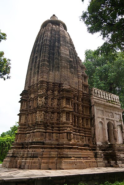
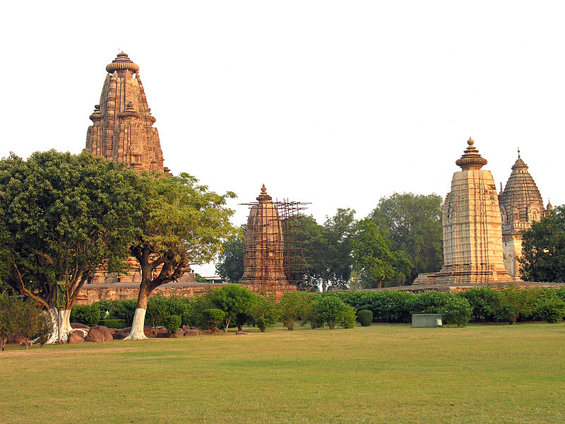
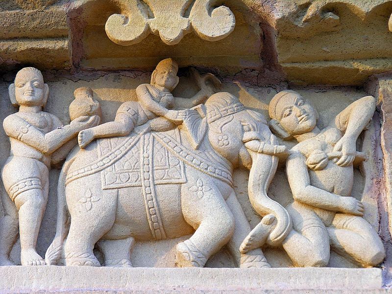
Khajuraho
The Khajuraho temples were built about 35 miles from the medieval city of Mahoba,the capital of Chandela dynasty, in Kalinjar region.
The Khajuraho group of temples belong to Vaishnavism, Saivism and Jainism - nearly a third each. All three types of temples were under construction at about the same time in late 10th century during the Chandela dynasty.Most temples were built during the reigns of the kings Yashovarman and Dhanga. Khajuraho temple site had 85 temples by 12th century. Of these, only about 20 temples have survived
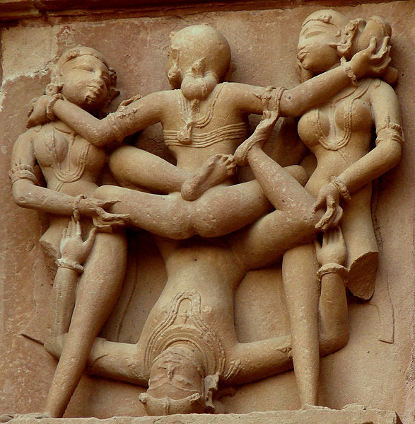
The temples are famous for their Nagara-style architectural symbolism and their erotic sculptures. In each group of Khajuraho temples, there were major temples surrounded by smaller temples - a grid style that is observed to varying degrees in Hindu temples in Angkor Wat, Parambaran and South India.
The Khajuraho temples are made of sandstone, with a granite foundation.The builders didn't use mortar: the stones were put together with mortise and tenon joints and they were held in place by gravity.
The largest surviving Saiva temple is Khandarya Mahadeva,(built in the reign of King Ganda from 1017-1029 AD, decorated with a profusion of sculptures with intricate details, symbolism and expressiveness of ancient Indian art) while the largest surviving Vaishnava group includes Chaturbhuja and Ramachandra.
Tope Left Clockwise: (1)Varah Temple (2)Lakhmana temple(3)Chaturbhuja Temple(4)Vamana Temple
In the 13th century, after the army of Delhi Sultanate, under the command of Qutb-ud-din Aibak, attacked and seized the Chandela kingdom. About a century later, Ibn Battuta, the Moroccan traveller in his memoirs about his stay in India from 1335 to 1342 AD, mentioned visiting Khajuraho temples.
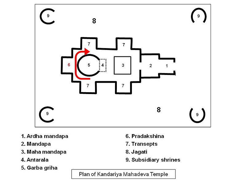
Architecture of temples:
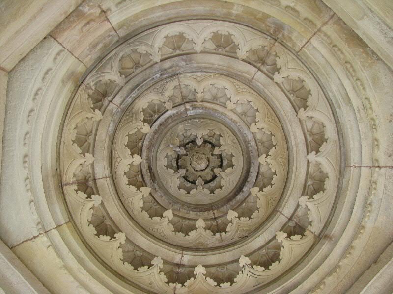
Following two figures:Khajuraho temples use the 8x8 (64) Vastu-purusa-mandala Manduka grid layout plan (left) found in Hindu temples. Above the temple’s brahma padas is a Sikhara (Vimana or Spire) that rises symmetrically above the central core, typically in a circles and turning-squares concentric layering design (right) that flows from one to the other as it rises towards the sky
Following two figures: An illustration of Khajuraho temple Spires (Sikhara, Vimana) built using concentric circle and rotating-squares principle. Four spires (left) are shown above, while the inside view of one Shikara ceiling (right) shows the symmetric layout.
Art and Sculptures:
The Khajuraho temples feature a variety of art work, of which 10% is sexual or erotic art outside and inside the temples.The erotic arts are part of Hindu tradition of treating kama as an essential and proper part of human life, and its symbolic or explicit display is common in Hindu temples.
Over 90% of the art work at the temple is about daily life and symbolic values in ancient Indian culture.
Kharwar
Kherari
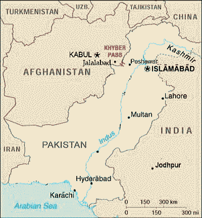
Khyber-Pass
Kibbanhalli
Kirkee/Khadki:
Kili-Ghul Mohammad
Kishangarh
Kishkindha
Kodaikanal
Kodekal
Kodikkari
Koil
Koldihwa (In Allahabad)
Kolhapur
Konark
Kondane
Kondavid
Korkai
Kot Diji
Kottayam
Kuchai
Kudatini
Kumbakonam
Kumbharia
Kumhrar / Kumrahar(Location same as pataliputra, Part P)
Kumhrar or Kumrahar is the remains of an ancient city of Pataliputra, Bihar.
The archaeological remains of the Mauryan period (322–185 BCE), has been discovered here, this include the ruins of a hypostyle 80-pillared hall. The excavation finding here dates back to 600 BCE, and marks the ancient capital of Ajatshatru,Chandragupta and Ashoka, and collectively the relics range from four continuous periods from 600 BCE to 600 CE.
Assembly Hall of 80-pillars:One pillar of polished stone, and a very large number of fragments were found. The excavators were able to trace 80 'pits' of ash and rublle on the site which marked the position in which other pillars must once have stood, giving the hall name – “Assembly hall of 80 pillars”. All the ruins are attributed to the Mauryan period
Maurya Hall Pillar
Anand Bihar: The foundations of the brick Buddhist monastery were excavated, apart from wooden beams and clay figures.
Arogya Vihar: found during the excavations, the presence of an Arogya Vihar headed by Dhanvantari, an early Indian medical practitioner, considered the source of Ayurveda.
TDurakhi Devi emple: Excavation revealed a detached piece of a carved stone railing of a stupa, with female figures on both the sides, giving it the name, 'Durukhi' or 'Durukhiya' (double faced) Devi, a specimen of Shunga art 2-1st century BCE. The figures are shown grabbing and breaking branches of trees, are Shalabhanjikas (the breaker of branches), the young women under a fertililty ritual. These images are presently worshipped in a temple-like structure.


%2B-%2B-%2BCopy.jpg)
%2B-%2B-%2BCopy.jpg)
%2B-%2BCopy%2B-%2BCopy%2B-%2BCopy%2B-%2BCopy.jpg)

%2B-%2B-%2BCopy%2B-%2BCopy.jpg)
%2B-%2B-%2BCopy.jpg)
%2B-%2B-%2BCopy.jpg)
%2B-%2B-%2BCopy.jpg)
%2B-%2B-%2BCopy.jpg)
%2B-%2BCopy%2B-%2BCopy%2B-%2BCopy%2B-%2BCopy.jpg)
%2B-%2B-%2BCopy.jpg)
%2B-%2B-%2BCopy.jpg)
%2B-%2BCopy%2B-%2BCopy%2B-%2BCopy%2B-%2BCopy.jpg)
%2B-%2BCopy%2B-%2BCopy%2B-%2BCopy%2B-%2BCopy.jpg)

%2B-%2B-%2BCopy.jpg)
%2B-%2BCopy%2B-%2BCopy%2B-%2BCopy%2B-%2BCopy.jpg)
%2B-%2B-%2BCopy.jpg)
%2B-%2BCopy%2B-%2BCopy%2B-%2BCopy%2B-%2BCopy.jpg)
%2B-%2B-%2BCopy.jpg)
%2B-%2B-%2BCopy.jpg)

%2B-%2B-%2BCopy.jpg)
%2B-%2B-%2BCopy.jpg)
%2B-%2BCopy%2B-%2BCopy%2B-%2BCopy%2B-%2BCopy.jpg)
%2B-%2BCopy%2B-%2BCopy%2B-%2BCopy%2B-%2BCopy.jpg)
%2B-%2B-%2BCopy.jpg)
%2B-%2B-%2BCopy%2B-%2BCopy%2B-%2BCopy.jpg)
%2B-%2BCopy%2B-%2BCopy%2B-%2BCopy%2B-%2BCopy.jpg)
%2B-%2BCopy%2B-%2BCopy%2B-%2BCopy%2B-%2BCopy.jpg)

%2B-%2B-%2BCopy%2B-%2BCopy%2B-%2BCopy.jpg)
%2B-%2B-%2BCopy%2B-%2BCopy%2B-%2BCopy.jpg)
%2B-%2BCopy%2B-%2BCopy%2B-%2BCopy%2B-%2BCopy.jpg)


%2B-%2BCopy%2B-%2BCopy%2B-%2BCopy%2B-%2BCopy.jpg)
%2B-%2B-%2BCopy.jpg)
%2B-%2B-%2BCopy.jpg)
%2B-%2B-%2BCopy.jpg)
%2B-%2BCopy%2B-%2BCopy%2B-%2BCopy%2B-%2BCopy.jpg)
%2B-%2B-%2BCopy.jpg)
%2B-%2BCopy%2B-%2BCopy%2B-%2BCopy%2B-%2BCopy.jpg)
%2B-%2B-%2BCopy.jpg)
%2B-%2B-%2BCopy.jpg)
%2B-%2BCopy%2B-%2BCopy%2B-%2BCopy%2B-%2BCopy.jpg)
%2B-%2BCopy%2B-%2BCopy%2B-%2BCopy%2B-%2BCopy.jpg)
%2B-%2B-%2BCopy.jpg)

%2B-%2B-%2BCopy.jpg)
%2B-%2BCopy%2B-%2BCopy%2B-%2BCopy%2B-%2BCopy.jpg)
%2B-%2BCopy%2B-%2BCopy%2B-%2BCopy%2B-%2BCopy.jpg)
%2B-.jpg)
%2B-%2B-%2BCopy.jpg)
%2B-%2B-%2BCopy%2B-%2BCopy.jpg)
%2B-%2B-%2BCopy.jpg)
%2B-%2B-%2BCopy%2B-%2BCopy.jpg)
%2B-%2B-%2BCopy%2B-%2BCopy.jpg)


%2B-%2B-%2BCopy.jpg)


%2B-%2B-%2BCopy.jpg)
%2B-%2B-%2BCopy.jpg)